The aim of my expedition was the rarely visited Atacama giant of Cerro Pissis which at 6776 m is usually considered to be the third highest peak in the Western Hemisphere. Being extremely remote, its altitude has never been determined reliably. In December 93 my friend Edgar and I tried to reach it by a new approach route from Chile. After three days of searching we located a suitable pass for crossing over into Argentina but time did not permit a serious attempt and we had to be content with an impressive view of five snow-covered peaks from 25 km away.
In March 1994 our driver, Giancarlo, took advantage of this new discovery to leave Bob Villarreal at 5000 m on the south-western side. Subsequently Bob was driven round to the north and a mining engineer helped Giancarlo to find another pass which shortens the route. The second attempt also failed (due to a self-inflicted injury) and hearing of the new route provided me with an incentive to have another go. Fortuitously, I had been given a compact GPS which would make such an objective even more worthwhile. Unfortunately, Edgar was unable to join me this time; hence the choice was to delay by a year or go it alone. Having already climbed Ojos del Salado (6885 m) solo in 1991, I decided to face the challenge, although this peak would be a much more serious undertaking because of its remoteness. Since base camp would be very high, I would need to spend some time beforehand at altitude. The Lauca National Park was chosen for this purpose; actually there are very few interesting places for acclimatizing in Chile (I have already been twice to San Pedro).
On 8 December I arrived in Santiago and after a chat with my old friends Arturo and Hugo I was soon on the plane north to Arica. Sadly time did not permit a visit to some of the best beaches in Chile. At dawn next morning I took a cheap bus to Putre (130 km for $4); at 3500 m a convenient staging post for Lauca. Here I had three nights comfortable stay at the CONAF (Chile Forestry Conservation) refugio. However, my time was marred by thunder, lightning and some heavy rain; in addition I was punished for enjoying a big lunch without being acclimatized. On the 12th I was back at the main road, hopeful of a lift to Parinacota. Two hours later I was on a truck bound for Bolivia which was barely able to make it up to the altiplano. The slow speed was ideal for watching flocks of vicunas grazing close to the road.
The tiny village of Parinacota (population 50) lies at 4400 m and is the last habitation before the border. It has a picturesque church with some old (17th century) murals which attract the daily tour bus from Arica. Here I stayed four nights at the comfortable CONAF refugio, sharing the Warden's room which even had TV. Because of my interests in wildlife conservation he invited me on his inspection tour the next day.
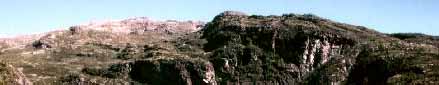
Finally we enjoyed some glorious weather, following heavy rain the previous day and overnight snow. Although it never rains at Arica, the so-called Bolivian winter may produce bad weather during the summer months. It was delightful to hike along numerous lakes and on easy gradients directly towards the snow-capped Parinacota volcano (6340 m). The lakes form a veritable bird sanctuary, with plenty of ducks, Andean gulls and flightless giant coots. We also got fairly close to flamingos on several occasions; at one place there must have been a hundred. There was much less evidence of animals; only two shy vicunas were spotted, although the rabbit- like vizcacha seemed to be common near rocky outcrops. Several vicunas had fallen victim to the puma and had to be buried under rocks. Understandably the Aymara llama herders at Parinacota do not take any chances and gather their flocks inside safe pens for the night. Only puma tracks were identified, but as a bonus we observed two nandu (similar to emu); being extremely shy they disappeared fast up a ridge. We returned in time to get photos of picturesque Aymara women attending the Christmas school party, some carrying babies on their backs.
Next day is spent visiting the huge Chungara lake at 4500 m. It proves easy to get a lift the short distance to the border but even so, a packet of cigarettes is much appreciated by the driver. I ignore the Coca Cola kiosk and start walking back along the lake shore. The backdrop of snow-capped mountains is impressive, with Bolivia's highest peak, Sajama (6500 m), in full view and the active volcano Guallatire emitting black smoke. The lake itself is rich in birdlife, particularly ducks and giant coots. Because of the altitude, several species are perilously close to extinction and the Lauca park is rightly a biosphere reserve. I enjoy watching the coots collecting reeds which are brought back to the mates who remain on small mounds, guarding the chicks. Two black birds with long curved beaks, very similar to the hadeda ibis, make a perfect motif for my camera; the CONAF display says that the cuervo is rarely seen by tourists. A solitary flamingo is reluctant to leave its favourite feeding place and allows me to approach quite close, achieving a perfect reflection of an imposing peak, punctuated by the flamingo showing its mirror image in the still lake. I finally reach the Chungara CONAF refugio and get the last seat on a passing tour bus. My last bird experience is quite amusing; a large woodpecker sits on a perch outside the church and seems to have adapted to its bleak surroundings with not a single tree in sight (it nests in the ground).
Next morning the Warden points me in the direction of another lake. On the way I encounter several large llama herds grazing on land made fertile by a network of small streams; they permit me to approach closely and it is particularly enjoyable to watch the youngsters. I follow the Lauca river on its meandering course and have to make several detours to avoid the wettest parts which are favoured by Andean gulls and terns. A large number of pink flamingos are feeding in the shallow lake, and there are also some grey ones. On the way back I absorb the beauty of this oasis, contemplating the stark contrast facing me in the Atacama. It is also delightful to watch a flotilla of coots displaying on the river; with periods of peaceful harmony interspersed by frantic skirmishes.
Having sampled some of the wildlife, my last day in Lauca is devoted to an ascent of Guane Guane (5093 m), accompanied by a guy who has climbed the fearsome active volcano Sangay. The clouds disperse as we ascend, revealing the next part. A flock of 20 vicunas is encountered; their uphill speed is impressive compared to our slow crawl. On reaching the last col, my young companion takes a rest while I scramble up the summit ridge in fresh winds. All the big peaks are hidden by clouds but many lakes and green pastures can be seen. After an excursion of five hours we return in time for hot lunch and transfer to the village square hopeful of catching a tour bus. As luck would have it, the usual company left early; however, there are some seats on a minibus. The departure is accompanied by heavy thunder and rain, but it only adds to my experience of this unique environment.
I arrive in Copiapo around 6 p.m. the next day, after a short flight to Antofagusta and a 7 hours bus journey - my third on this distance. Being a Saturday, I am lucky to find one store still selling the vital white gas for my MSR stove. Sunday is spent washing clothes and getting ready. I meet two young guys called Patricio (Pato) who will come along to base camp in order to learn the route. This is Giancarlo's last big trip before going to work for a gold mine in the Atacama and the first for the new company, but I am assured they are professionals and hearing about their rigorous training removes any doubts from my mind.
We leave at dawn on 19th in Giancarlo's new (1982) Toyota land cruiser which feels like a tank with its internal steel cage and huge tyres. In about 3 hours we reach the col (3900 m) overlooking Laguna Santa Rosa, where the real Atacama begins. Skirting the lake (my third time), flamingos can be seen feeding. Soon we pass the Marte mine which has expanded into a compact village. Another 10 km further on we leave the road and head east into the wilderness, officially known as Puna de Atacama. The illegal crossing into Argentina is made at the Valle Ancho Norte pass which is gained without much effort. A small steel tower marks the border, with an altitude of 4672 m registered by the GPS. It is comforting to establish good radio contact with three locations in Chile. Soon Pissis itself can be seen, partly hidden in a huge cloud. Although Giancarlo has been this way before, the route is tricky and he has to backtrack several km at one place. Now the vehicle is really put through its paces; it seems unstoppable as we encounter sizeable rocks and crawl up steep slopes. The last ridge is rough but after 7 hours we reach the bottom of the northern glacier, some 50 km from the border and 260 km from Copiapo. We celebrate in traditional Chilean style by opening a 12 year whisky, using snow for cooling (a novelty for the low-landers).
Having reached their objective, my friends do not stay long. We agree to meet at noon on the 28th by the red flag which now marks base camp but will later be moved back to the brow of the hill. The possibility that either of us might miss this rendevouz is too nerve-racking to be discussed (it did happen on Ojos in 91 when I had to walk out 20 km). Looking around for a good camp site, I see a likely place some 300 m away. However, this would involve ferrying all my gear across a snow field, and since it is also snowing I accept the temporary discomfort of sleeping on sloping ground which is levelled a little by my efforts. Maybe it is the altitude effect but I struggle for an hour to fit the fly on my brand new tent, trying in vain to locate a symmetry point in the middle and there is also a fresh breeze to contend with. As usual in the Atacama, the wind dies down towards the evening and I can cook supper; freeze-dried fettucine seems a good choice for the first night. Base camp is at 27-44-26 S, 68-45-47 W, with the GPS measuring 5375 m and an error of 70 m, consistent with the altimeter which was calibrated to the GPS at the border pass. It is reassuring to have running water near by but in the event my own cleaner supply is sufficient.
My first day is intended for taking it easy so I can get used to the new conditions. After lunch I wander up in a south-easterly direction searching for a possible camp site. A promising place is found, with a slight trickle of water near by, but it does not seem high enough for a summit attempt. Exploring further, I gain the beginning of the main eastern ridge crest at 6000 m which provides excellent views of possible routes on both sides of the glacier. Since I am not prepared to solo the whole glacier with its steep upper part (although this would be the quickest way), a choice must be made between the two sides. From the published position of Pissis (1994 edition of `Mountaineering in the Andes' by Jill Neate), it would appear that the main summit should lie 5' to the west and 2' south of base. However, considering the rather large displacement from my camp (about 10 km), I decide to ignore this information. From my vantage point I had seen that the western side would be more direct but possibly a bit problematical. The most likely area for camp site (the top of a scree slope around 6000 m) appeared to be virtually snow-less, with no prospect of finding water. Since my stove has been behaving in an erratic way, the eastern side has to be chosen, and I can only hope that my stamina will get me up the longer route.
Next morning the stove refuses completely, and is put on one side for later attention. I fill the small sack with most of the food and carry up to the intended camp site, placing the vital load inside a big hollow rock for safety. Clouds gather and by late afternoon there is an hour of hail and extremely heavy thunder. The stove gets cleaned but cannot be used because the bad weather returns. I postpone cooking dinner until the morning but the stove is still reluctant. By noon I move camp, carrying an extra 4 litres of water; a second 10 litre container proved sufficient for base camp use. The food sack is retrieved and I reach my new camp just as the weather starts to deteriorate. By the time a platform has been levelled it is becoming unpleasant but I am soon sheltering in comfort, entertained by impressive thunder. Yet again the conditions do not allow any cooking so I have to rely on my large emergency stock of chocolate-coated marzipan.
My fifth day grants me just one perfect hour. I fill the container with clean water from the slow trickle which emerges below a snow field. The hail is back again by early afternoon, turning to snow which falls so silently one cannot hear it, except for small avalanches from the tent. It looks like a white Christmas in the Atacama, and I am beginning to wonder about being trapped by heavy snow fall. However, this time the thunder is much weaker and seems distant, so maybe this is the turning point. The GPS location of my tent is at 45'6'' S, 45'34'' W, with an altitude of 5670 m which agrees with the altimeter. Unlike previous nights, the wind does not die down, adding to my feelings of uncertainty.
Looking out the next morning is quite a revelation, with clear views across to the giant peaks of Tres Cruces, Ojos del Salado and Incahuasi, and two green lakes in the middle distance. As if inspired by this magical view, the stove makes a sudden noise and increases its strength without any intervention. I set off to check the route, reaching the 6000 m ridge while suffering in the heat. On further inspection I decide to tackle the long scree slope, rather than follow the main ridge over the two south-easterly summits, before crossing the glacier at the top. It seems straightforward to traverse underneath the middle summit and aim for the snow-covered western summit which can just be discerned and is most likely the highest. Before returning, I place some markers across the broad ridge to a natural access point on the far side and record the position in the GPS for emergency navigation. Further snow showers hit the tent in late afternoon but it clears up again in time for a late dinner.
For Christmas Day I had planned a small excursion, since the weather might still be unreliable. I set off at 10 in a south-easterly direction, aiming for another ridge which is reached three hours later. At this place (6300 m) there is a good view across to a summit not visible from camp. I estimate another three hours to the top by an easy route and decide to risk the weather. Traversing towards a short glacier tongue, I cross a steep snow field to save time. The deterioration in the conditions on such a short distance takes me by surprise and I have to make a desperate effort of step- kicking, supported by the ice axe, in order to avoid falling. The glacier crossing itself is level; I then follow an obvious feature which leads diagonally towards the summit, with plenty of rocks for firm foot-holds. I reach the top ahead of schedule and spend some time measuring the altitude and position in freezing conditions. The most likely candidate for the neighbouring giant Bonete is identified and photographed. There is no evidence of previous visits to this outlying peak (46'39'' S, 45'10'' W) and the GPS value of 6466 m with error 45 m (6360 m by altimeter) makes the effort worth while; at least I have made one significant summit. The return is shortened by skirting the ridge, following the glacier. On arriving back in camp I find the tent has been compressed several feet by a sharp gust of wind; it has no anchor for guy lines at the ends. It it is impossible to cook anything for Christmas dinner so I celebrate by opening my present, a yuletide chocolate log filled with rum.
A windy night kept me awake but it did not feel cold; -8 C was measured inside the tent by the minimum thermometer. Because of the previous day's effort, it seemed desirable to take it easy. In any case, it would not be feasible to make two serious attempts in the remaining two days, and by delaying there might also be a chance of better weather and the extra night will also be beneficial. The morning is absolutely glorious; I spend much time gazing out over the virgin landscape, directly towards my old adversary, Ojos del Salado some 100 km away. I take the opportunity to cook an early dinner, then go for a stroll. When I get back around 5 the weather starts deteriorating, with light snow showers and distant thunder but in an hour it has eased off again. I can only hope that the Atacama will finally grant me one good day.
Summit day begins well with a dawn start at 6.30 after brewing tea. It feels cold, which is a good sign, and the ridge plateau is gained in just one hour. Now begins the long traverse which is quite tedious. My time estimate of two hours is clearly unrealistic; several hidden gullies slow progress and it is tempting to head up to the ridge which would involve a descent to the glacier later (but might still be the best strategy). However, I persevere, sometimes finding small snow fields for better grip. Unfortunately I am forced to take an hour's rest during a snow shower, hoping for a respite. The glacier crossing point is reached about 1 p.m., some three hours behind schedule. The first part of the glacier is sloping, then it gets easier but new snow builds up underneath the crampons and the absence of wind here makes for a hot microclimate. In any case, crossing without crampons would have been risky since some places only have a thin snow layer on top of the ice. At the other side I keep the crampons on in order to make faster progress on the scree. The route is now obvious but as usual there are hidden sections and on two occasions I have to descend a bit. Some distant snow showers can be seen but summit fever dispels any caution. The last ridge to the apparent summit is steeper, with mixed snow and rock. I become aware that the front half of one crampon is missing so the other piece is removed. It is a slight disappointment to find that the highest point is a little further, but it could have been worse and I finally make it after 10 hours.
The summit cairn holds a cylinder with evidence of a 1985 expedition, as well as an undated Argentinian official document, and I can only hope it is the highest point. In freezing cold and wind I manage to photograph my summit sack with flags and take some macro shots of the GPS which shows 6895 m with 50 m error at 27-45-17 S, 68-47-56 W, whereas the altimeter reads 6710 m (consistent with expectations). Again Bonete is prominent to the south, but there is no time to linger and I leave shortly after 5. Fortunately traces of my foot-prints show the way across the small but featureless summit plateau, after which it becomes easier since the route looks familiar. The missing crampon part is recovered but I assume (wrongly) it is damaged and limp back on the good one. The glacier crossing poses no problem but later I have to take care when descending on the sloping edge of the glacier (which may have holes) to save time. This still leaves a lot of scree to negotiate and I begin to slow down, needing frequent short rests. My total food intake has only been 100 gm of marzipan and about one litre of flavoured water. Long shadows start appearing on the desert below, producing vivid colour contrasts as the sunset develops. A final effort gets me up to the ridge which must be crossed, and I stagger into camp at 9, only ten minutes before darkness. The risky strategy of not carrying a torch to save weight was based on the ability to locate the tent at the bottom of a small snow field in the dark. Although it is late, I replenish my liquid loss by cooking bullion and soup while gazing at the incredibly sparkling sky.
On 28th I take it easy packing up and finally leave camp around 11.30. Cresting the brow of the hill, I spot the stationary jeep in the distance. I wave my arms to show appreciation and hear the siren as if in acknowledgement. The snow field is crossed at noon and passing base camp, I pick up some minor items and the garbage before approaching the vehicle. It is only then that the drivers see me; they were hooting in the hope that I would be aware of their presence. It turns out that they arrived at 9.30 after a perfect trip, having left home very early from sheer excitement. Now it is my turn to open a small bottle of brandy which has remained intact throughout; it also serves a medicinal purpose for my neglected stomach. The way back is not without troubles. Almost at once the English-speaking Pato drives into a large stone which is stuck underneath (I was too polite to tell the driver). Using his army engineering experience, he manages to ease the vehicle over a makeshift bridge without incurring any serious damage. Retracing the route proves difficult and we are delayed by several false trails. At times we leave the valley and charge uphill, then drive along precarious ridges which do not always permit a safe passage. Not surprisingly after such treatment, the engine is also feeling the strain but now both Pato's act in unison and replace a newly installed faulty item by a spare which luckily has not been discarded. The engine is still hesitant and we barely crawl up to the border pass. However, my confidence in the drivers is justified and we finally roll into Copiapo by 9.
Postscript.
According to the Defence Mapping Agency Report, the GPS readings should be decreased by 20 m for reduction to the local spheroid. There is also a small reduction in latitude and longitude of 1'' and 2'', respectively. The altitude of Pissis is therefore comparable to Ojos del Salado (6885 m) within the formal errors. However, the presence of an additional error due to so-called Selective Availability cannot be excluded, although this seems unlikely in view of repeated determinations at the camps which gave similar results. Moreover, the lower value of 6710 m obtained by the Thommen altimeter is consistent with expectations since a difference of about 100 m was measured on the south-east summit, when the readings agreed in camp.
Sverre Aarseth