Ojos del Salado (1991)
Immersed in a thermal pool in the middle of nowhere, I try to forget about the next move which is going to be a back-breaking experience. Instead I count my luck of having met Hugo in Santiago who put me in touch with the only likely driver who would take me to the base camp of Ojos del Salado, at 6883 m the acclaimed second highest peak in the Western Hemisphere. The day before Giancarlo had driven me up from the oasis of Copiapo to the border police station at 4500 m which would be a suitable staging post after my previous acclimatization in lovely San Pedro de Atacama, with visits to the geysers and ascent of the active volcano Lascar (5600 m). To my surprise, I am supposed to have a permit but this obstacle is surmounted by my driver promising to get it from a friend in the local police on returning. His jeep could reach the first hut at 5200 m but this would be too high so I put up my tent next to the burnt-out refugio. After next day's excursion to the azure-coloured Laguna Verde with its primitive spa facility I spend one more day psyching myself up for the big carry. Having read of another party (in cars) spending several days to find the hut is not exactly encouraging.
On the dreaded day I trace the tyre markings along the bleak desert trail. The tent and ice axe are left behind but my extra load of six litres of water and 1 kg marzipan makes 20 minutes carry an agony. When I finally reach an area at 5000 m which corresponds to the description `here we parked and walked up', the track becomes invisible but I spot an object with sharp edges and head up some hills. Having expended extra energy I realize it is not the hut but the view now brings out faint markings. I descend a little and follow their direction. My spirits are revived when the road from the upper refugio can be seen and it is only a question of time before the Atacama refugio comes into view. Reaching it, my weary body collapses on a bed after 10 hours hike. Following a restful Christmas Day, I do an easy carry to Tejos (5750 m) and find a small source of water. On the way down my peace is disrupted by a truck; the passenger whom I met at the road-head is hoping to get a summit picture of his sponsored mountain bike (named the `Oxford' of all things, whereas I am a Cambridge man!). Two days later I join him in the comfortable hut after a brisk hike which beats the book entry of 90 minutes by two Brits.
On summit day we leave together at 6 but an hour later my companion reaches his bike and falls behind. The first part is up rocks which makes for good progress but then comes the inevitable scree slope. The crater rim (6700 m) is gained in 5 1/2 hours but there is a sting in the tail. Hugo has warned me of the final summit towers - and advised against doing them alone - but their appearance still have a dramatic impact. After some rest, I follow a trail which skirts the snow-filled caldera and leads to the col, where as advertised there is a rope for assistance along the summit ridge. The last 25 m is a walk and soon I stand on the summit 7 1/2 hours after setting out. The wind is biting cold and my camera only manages an inferior picture of my sack by the cairn. Having ascended the official summit, I am tempted by the other one which rises from the col. The height is modest but the ground is unstable. Using the loose end of the rope, I lower myself over the col from where it is easier to gain access. Hugo (who has guided on Ojos before) was right: if you fall here, you fall a long way! But I scramble up without mishap and find a second summit book. The Thommen shows almost 6780 m, whereas the reading was 6770 on the main summit (the deficiency of 110 m is typical), but at least I have made sure.
Taking a rest halfway down the boulder field, I see Louis pushing his bike along the snow. He carries it up and desperately wants to make the summit. By now it is nearly 4 and I insist it cannot be done; in any case there is no time. He accepts my spare bottle of water and agrees to delay his attempt. Next day still leaves me feeling weak but it is an easy stroll to the lower refugio where my driver is supposed to pick me up. With no vehicle appearing by 2, I decide to walk out and hope that one litre of water will be enough. The sack is light but the desert wind dries my mouth. Around 5.30 I see a car standing in a flat part. However, my spirits are dashed when I find it empty and see foot prints leading back. All the water is gone when I reach base at 7 to find Giancarlo and two companions in my tent and one belonging to another expedition. The four-wheel drive had failed and the six km walk required many rests for the Copiapo (300 m) residents. I give them all my warm clothes and spend a sleepless night but at least the police radio has called for a rescue vehicle and nobody asks about the non-existent climbing permit. As it turns out, the Hertz car is unable to pull the stranded jeep out but we all squeeze in and head back to civilization. After experiencing the desert in slow motion, it is exhilarating to move along at speed and take in the vast and wonderful scenery which leaves an unforgettable imprint.
Pissis (1994)
Having spent the previous year accompanied by my friend Edgar and with Giancarlo as driver in an unsuccessful search for an approach to Pissis from Chile, I decided to try my luck again going alone. This time Giancarlo had done his research and together with a mining engineer found a more direct route on the return trip with a client. A rarely visited mountain, Pissis provided a unique opportunity for using my newly acquired 60th birthday present to make a GPS determination of its uncertain altitude. Unlike Ojos, there are no huts and its extreme isolation presents a daunting challenge for an unsupported visit (another group cancelled because of its remoteness). My preparation for the expedition consisted of spending seven nights in the splendid Parinacota National Park, albeit with three nights at sea level before leaving for base camp. Again Giancarlo is at the wheel but he is retiring and handing over to Patricio and a friend who are coming along to learn the route.
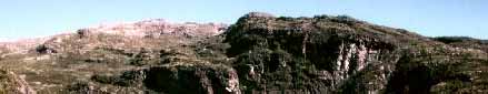
Soon after passing Mina Marte (4000 m) we leave the road and head for the Valle Ancho Pass (4500 m) which also sports a border marker. Crossing illegally into the old adversary Argentina is especially exciting for the Chileans. There are no trails to be seen and the route-finding becomes tricky, with the occasional backtracking. Soon Pissis shows itself; it is an impressive sight although partly engulfed in a snow storm. We are aiming for a well defined spot at the bottom of a huge glacier which is reached after 7 1/2 hours and 270 km. At $400 per trip, it feels like the cheapest taxi ride in the world, considering the terrain which is littered with rocks. The three locals celebrate with a 12-year whisky on the snow before leaving me behind to my uncertain fate. The first task of erecting the tent proves tricky in the fresh breeze; losing the fly now would be a bad start. The platform is sloping slightly but arriving at 5400 m from the lowlands is not conducive to great exertion and my stay will be short.
My first day should be restful but I wander up a possible route to the next camp and find a small snow field at 5700 m. Ascending further, I reach the top of a ridge at 6000 m which yields good views of five well separated peaks but it is impossible to pick out the highest. In any case, proceeding up the eastern side of the glacier appears the best bet since no obvious camp site - level ground and snow - can be seen on the other side. The food sack is carried up to a safe place the following day and I return to endure hail and thunder which prevent cooking. Fortunately next morning is perfect and early dinner is prepared, although now the stove (my only one) is rather reluctant. I move camp and manage to level a platform before the afternoon hail sets in. Miraculously a small trickle of water appears when digging a hole at the edge of the snow field. Enduring some frightening thunder and lightning over several days, I am thankful for not having placed my tent on the exposed ridge above.
Two days later I brave the elements and return to the ridge for a final assessment. My initial plan still looks good and I decide to ascend the scree slopes and cross the glacier higher up where it seems to level out; then traverse to the most distant and probably highest peak which is barely visible. Accordingly I place some markers along the route as guide for possible late return or bad visibility and get back in time to avoid a vicious snow shower. Christmas Day is my last chance to gain altitude before the final climb. I explore further to the east, reaching the end of a ridge at 6300 m. A tempting summit is in full view across a small valley and I give myself three more hours to reach it. The hike is easy and I actually beat my estimate. This eastern outlier is at 6446 m and does not show any evidence of previous visits. On returning I find the tent compressed by a strong gust of wind and the conditions do not favour any cooking, so there is not even a cup of tea for my Christmas dinner; however, the marzipan proves its worth. Next day I make sure of an early dinner. It is also my last chance to gain strength before gambling everything on the ultimate day. True to form, some late snow showers develop but the thunder seems more distant which makes me hopeful that the gods will relent when I go for the top.
I get off to a good start and watch the sunrise shadows shortening in the desert below as the ridge is gained. The next stage turns out to be much longer than the two hours envisaged. There are a number of hidden depressions and I sit out a snow shower, the only one that day. The glacier crossing is reached at 1, some three hours later than estimated. The glacier appears safe at this point since the curved parts further down do not show any crevasses. I keep the crampons on to save time and proceed over gently sloping rough ground partly covered by snow. Once more it is a good deal further than first impressions but the summit fever is too strong to turn back. Gaining a false summit, I notice that half a crampon is missing. Finally I reach the highest point shortly before 5 and find a cylinder containing names but no official statement. Looking around, I see two other humps of similar height but there is no time to investigate so I hope the cylinder is placed correctly. Several measurements are made with the GPS which gives strong signals and small errors (50 m either way). The best determination of 6874 m is arrived at after deducting 20 m due to the local deviation from the geoid, whereas the altimeter which was calibrated in camp shows an expected lower reading of 6710 m.
After a brief stay and some picture taking I head for home. The altitude confuses my sense of direction since the summit area is featureless but a few foot prints point the way. It is cold and already my pace is slow due to lack of energy. The missing crampon is recovered but not reinstated. On crossing the glacier I gain some time by avoiding part of the scree slope and descend near the edge of the snow field, which has icy patches, hoping the faulty crampon will not let me down. It is my luck that the visibility holds up until sunset. Re-ascending the final ridge is painfully slow, with frequent rests, but there is no other way. I reach the tent around 9, with ten minutes to spare before it gets dark, but the location at the bottom of a snow field would have acted as a guide later. Going without dinner, I derive inspiration and satisfaction by admiring the incredibly sparkling sky.
My last day provides a complete contrast from ten days of solitude. The vehicle has been booked to arrive at 1 so I am in no hurry. However, coming down the slopes I see the jeep standing next to my red marker flag. The drivers were so excited that they left Copiapo long before dawn and got here hours ago. I open a small bottle of brandy to mark the happy event, trying not to think of the alternative scenario with them or me not making it. Immediately on leaving base, the car hits a big rock and gets stuck. This requires building a stone bridge which we can slide over, and amazingly there does not appear to be any damage. Later the engine begins to lose power for unknown reasons and is very hesitant uphill. Not surprisingly, it is more difficult to find the way without an obvious landmark but after several false trails we eventually reach town by 9, in time to celebrate the success.
Llullaillaco (1998)
After four years, the memories of hardship fade away and I find myself on the Atacama trail yet again. This time I am sharing transport and camp sites with Bob who has visited the desert many times. We are driven to 5000 m on the remote Llullaillaco (6732 m) which ranks seventh in the Western World and is known for its ancient temple on the summit. (See National Geographic, November 1999, for description of treasures found at the summit.) With no prior acclimatization, except for a night on the way at Aguas Calientes (3600 m), it is necessary to take it easy at first. After three days of hanging around, I hike up to our next prospective camp and find a tiny snow field next to the only flat area around 5500 m. Following a day's food carry, we move up in shirt-sleeve weather but four hours is long enough in my present condition. After a sleepless night we set off for the next stage with food sacks. The scree slopes are agonizing but I am not prepared for the shock announcement from Bob, who is trailing. He has had enough and is quitting. I reach the crater rim (6100 m) in six hours and have a stunning view of the false summit some distance away. There is a big snow field close by and plenty of level ground.
After a well deserved rest day I leave Bob behind but benefit from exchanging my temperamental stove which does not inspire confidence in spite of being checked out. This time it takes 7 1/2 hours but there is still ample time for cooking. Two days later, after a night of -10 F outside, I make my first attempt without moving higher, which was suggested by Bob who has climbed the false summit. However, the route is problematic and I choose the eastern side, hoping to gain the long summit ridge. The early part is easy and only one snow field requires crampons, after which they are left behind to save weight. I gain the ridge and proceed upwards for a while before realizing that the actual summit ridge is the next one over, separated by a valley which would take too much time. My eyes have been misled by foreshortening and now there is no choice but to carry on, hoping for the best. There are large blocks to negotiate and the wind becomes intensely cold. In addition, I have to contend with the most debilitating dry cough which has bothered me since day one. At 3 I reach a point where the ridge abuts slightly before the col, although it should be possible to complete the climb with a scramble. The pointed summit looks tantalizingly close some 200 m above. However, the weather conditions make such thoughts impossible and I have no choice but to retreat: it is the first time I have turned back on a solo climb.
On the way down I avoid the tricky ridge by ascending the adjacent snow field which starts at the col. However, care is needed to avoid falling into large holes near the rocks and the lack of crampons makes it hazardous to negotiate icy patches. I am greatly relieved when the ordeal is over. The rest is a stroll, but I am weak and need frequent stops before reaching the tent with two hours until sunset. With an extra day in hand, I do not have the energy for another attempt and must be content with carrying back images of magical Atacama.
This article is dedicated to the memory of Giancarlo Fiocco, who pioneered the route to Pissis from Chile and perished by exposure within sight of the Mina Marte.
Postscript. It appears that in the GPS altitude determination, the deviation from the geoid should not be subtracted when using the WGS 84 datum. In that case the measurement for Pissis should read 6894 m, with an error of 50 m.
Sverre Aarseth
(Published in the Alpine Journal 2001)